Showing posts with label redevelopment. Show all posts

Friday, April 13, 2007

You're Hired

The New Orleans City Council voted unanimously to sell city property located on Poydras St. to Donald Trump to build his Trump International Hotel & Tower.

If you've got an extra $300,000 you've been looking to invest, you may want to bid on a 3,500-square-foot piece of land in downtown New Orleans.

But you might have to outbid Donald Trump to get it.

The City Council has authorized the sale of a small chunk of city-owned land that is part of the site of the planned 70-story Trump International Hotel & Tower.

The 1.6 million-square-foot tower, estimated to cost about $400 million, would fill most of a largely vacant block. It would be 716 feet high, plus a 126-foot spire, and would contain 734 luxury condominium and hotel units and a 715-space garage.

Developers have said they hope to break ground this summer on what would be Louisiana's tallest building. Construction is expected to take 28 months, putting completion in late 2009.

At its April 5 meeting, the council gave unanimous approval to selling its piece of the site, a 106-by-33-foot plot in a block bounded by Poydras, Camp, Natchez and Magazine streets. The minimum price is $300,000, with 10 percent due in cash immediately. The city reserves the right to reject any or all bids.

The city also retains a "right of first refusal and option to purchase" the property for 10 years or until a building "assessed for ad valorem tax purposes" at not less than $50 million is built on the site.

In other news at the council meeting, a major local developer, HRI Properties, withdrew its application for a conditional-use permit for an $85 million, 10-story luxury condominium and apartment building in the Warehouse District.

HRI, the company led by Pres Kabacoff, wanted to build a 357,000-square-foot building with 221 apartments on the lower five floors, 105 condos on the upper five floors and a 509-space parking garage. The project would have included most of the block bounded by Andrew Higgins Drive and Constance, Poeyfarre and Annunciation streets.

Most of the 2-acre site is now a parking lot, but plans called for demolishing a small Pelican Ice & Cold Storage building at Andrew Higgins and Annunciation. The building would have lent its name to the new project, to be called the IceHouse Residences.

When it presented its plans to the City Planning Commission last year, HRI said it hoped to start construction by June, with the garage to be completed within a year and the residential building within 18 months.

The project needed a conditional-use permit and several other city approvals, including an 18-foot waiver to the normal 100-foot height limit.

The Planning Commission endorsed the project in December despite opposition from several residents of another building that HRI manages, the Cotton Mill condo building across the street.

Tara Hernandez, an HRI executive, said this week that the company has dropped the IceHouse project because it "no longer has site control." Richard Cahn, who owns the site, became concerned about repeated delays in getting the project under way, Hernandez said.

She said HRI might try to revive the project someday if it can regain control of the site.

Generally speaking I'm in favor development/redevelopment downtown and don't necessarily think that the Donald's project is a bad thing. However, overdevelopment is always a risk. The Trump International Hotel & Tower is a very large development and if the rooms/units can't be filled, a decaying tower will change the CBD from a shining beacon for business and commerce to a reminder to everyone that New Orleans is a dying city.

But I'm an optimist. Donald Trump didn't get where he is by investing in losing propositions.

Thursday, March 29, 2007

Wild Wild West

New Orleans' recovery czar is proposing seventeen recovery areas that will receive money for redevelopment/rebuilding.

Dr. Edward Blakely, Executive Director of Recovery Management for the City of New Orleans, today announced the first 17 targeted recovery zones that will spur redevelopment and accelerate our recovery. The zones will be built around public assets in key business corridors in an effort to generate further private investment from developers. "These recovery zones represent a critical component of our rebuilding, "said Mayor C. Ray Nagin. "We will continue to leverage our limited resources to accelerate our recovery. Our citizens will benefit from the higher quality of life that will result."

Target areas are consistent with the development approaches citizens suggested in earlier redevelopment plans, such as the Unified New Orleans Plan, the Lambert Plan and the Bring New Orleans Back Commission plan. The city will provide loans and other incentives to developers interested in investing in key locations within the zones. The zones are generally high visibility sites, with sufficient land and other assets. They also have a high potential to attract investors and possess adequate resources to catalyze development such as schools and libraries.

"The development zones will spur activity from investors," said Blakely. "When one area starts to do well, investors will want to invest nearby. This will allow the city to redevelop wisely and will help residents make smart choices about where to rebuild.

The zones take three formats:

Rebuild areas have experienced severe destruction of physical structures and social networks. These areas will require major rebuilding, or significant public and private investment in order to recover.

Redevelop areas are places where some recovery components and resources are already present. They have a high potential for attracting investment and acting as a catalyst for further redevelopment and recovery of the affected community.

Renew areas include specific projects that require relatively modest public intervention in order to supplement work already underway by the private and nonprofit sector.

Each development zone is approximately one-half mile in diameter, although the area can vary slightly. The first zones are:

Rebuild

1. New Orleans East Plaza
2. Lower Ninth Ward

Redevelop

1. Carrollton Avenue at Interstate 10
2. Harrison Avenue (Canal Boulevard to City Park)
3. Gentilly Boulevard at Elysian Fields
4. St. Bernard/ AP Touro at North Claiborne Avenue
5. Broad Street at Lafitte Greenway/Treme
6. South Claiborne Avenue at Toledano

Renew

1. Canal Street (Downtown)
2. Broadmoor (R. Keller Center and Library)
3. Tulane Avenue at Jeff Davis (Comiskey Park)
4. O.C. Halley Corridor
5. Bayou Road/Broad Street Cultural Corridor (Market Building)
6. St. Roch Street (Market and neutral ground)
7. Freret Street (Farmers Market)
8. R.E. Lee at Paris Avenue (Lake Terrace Center improvements)
9. Alcee Fortier Street (Street Beautification)

In addition to the recovery areas, the City plans to invest in projects throughout New Orleans. These include park improvements, street and traffic signals and other programs designed to spur investment and enhance the quality of life.
Dr. Blakely described the process as the wild wild west where pioneers put down stakes and people build around it.

Monday, February 12, 2007

Breaking Away

East Baton Rouge Parish has recently completed the Mississippi River Levee Bicycle Path from downtown Baton Rouge to the LSU campus. Some would like to extend it all the way to New Orleans.

A recently completed stretch of paved bike path that runs atop the Mississippi River levee from downtown Baton Rouge to LSU soon could be extended all the way to New Orleans.

The proposed levee bike path would run an estimated 110 miles and cost an estimated $33 million.

The first step is to complete a $250,000 master plan that could qualify the project for federal funds likely to cover 80 percent of construction costs. The other 20 percent would come from local and state sources.

Pete Newkirk, public works director for the city-parish government, said he plans to ask the Metro Council Wednesday to chip in $12,500 to help fund the $250,000 study.

Bruce Wickert, an experienced cyclist who the heads the local Metropolitan Planning Organization's Bicycle and Pedestrian Committee, said a bike path has already been constructed from Audubon Park in New Orleans north almost to Norco.

Wickert said that if the proposed Mississippi River Levee Bike Path becomes a reality, it will likely be used in segments for recreational purposes.

"But you could travel the whole 110 miles about six hours at a moderate pace of about 17 mph," Wickert said.

East Baton Rouge and Jefferson Parishes are now in the breakaway, the state needs to suck wheels and catch up to get the project going.

Thursday, January 18, 2007

Beware What You Ask For...

The city of Vancouver's city planners wanted more people living downtown. The problem is, more people are living downtown.

When Simon Lim, president of the Holborn Group, bought a one-block building site in downtown Vancouver last summer, he had plans for a hotel and a commercial and condominium complex. But a few months later, city planners proposed rezoning the site, which is known as the Bay Parkade. The change would require Mr. Lim to double the amount of commercial space, with priority given to a new office tower.

“I have to admit when I first caught wind of this policy change, I wasn’t exactly a happy puppy,” said Mr. Lim, who is developing another downtown hotel-condo project, called Vancouver’s Turn. “I suspect there is some profit in developing commercial, but it is significantly more profitable to build residential.”

Over the last 15 years, downtown Vancouver has become a leader in North America’s urban housing renaissance. Under Vancouver’s “living first” policy, which was adopted 20 years ago, the downtown population has increased to 80,000 from 40,000, out of a total city population of 600,000. By 2030, planners expect 120,000 people to live in the city’s shimmering glass skyscrapers, which overlook the snowcapped North Shore mountains, English Bay and Coal Harbour.

But now, city officials and businesses are concerned that downtown Vancouver may become a victim of its own success, and that residential development will encroach on jobs and office space. Officials put a moratorium on new housing near the business district two years ago, after allowing two condo towers — one called Living Shangri-La — in what was supposed to be a commercial-only zone.

New Orleans is currently seeing a similar trend with more residents moving away from lower, flooded neighborhoods to the high ground, specifically downtown, the Warehouse District and parts of Uptown.

While people moving Uptown is not a problem as it is primarily residential. However, New Orleans' city planners need to beware not to push this too hard. Downtown and the Warehouse District have been historically businesses. Residential condos are a recent phenomenon. The goal of many of these city planners is to create mixed use developments so that people don't have to go very for for work or shopping. That is part of the appeal of living downtown. Otherwise we will end up with suburbia in the middle of downtown.

Monday, January 15, 2007

"Damn the torpedoes, Full speed ahead!"

The National WWII Museum (formally National D-Day Museum) is moving forward with its plans for a $300 million expansion.

After Hurricane Katrina, many people expected the National World War II Museum to abandon the ambitious expansion program it announced three years ago, its president said last week.

The museum's board of trustees felt differently, museum President Gordon "Nick" Mueller told the New Orleans City Planning Commission.

"This museum is about the American spirit, and we thought we had to display a little bit of that spirit," Mueller said.

"Things were tough during World War II, too," he added.

As a result, even before fundraising is complete, the museum is ready to begin demolishing several buildings in the 1000 block of Magazine Street and constructing the first phase of an expansion that, once complete, will quadruple its size and help attract as many as 750,000 to 1 million visitors a year, three to four times as many as it was drawing before Katrina.

Officials hope to put the work out to bid by March or April.

From the WWII Museum website:
Voorsanger Architects, PC of New York City was chosen as the architectural design firm and Gallagher & Associates of Bethesda, Maryland, as the exhibition design firm in a design competition for the Museum’s capital expansion. Bart Voorsanger has gained wide recognition for projects in Europe, Japan and the United States on museums, universities and airport architecture. Recent projects include the Asia Society Museum, the master plan for the University of Virginia and the renovation of Terminal B at Newark Liberty International Airport. Gallagher is a full-service design firm with expertise in museum planning and exhibition design. The firm has worked with the Smithsonian Institution, the International Spy Museum and the Newark Museum. The firm is currently designing the Visitors Center for the American Cemetery at Omaha Beach in Normandy. Mathes Brierre of New Orleans has been selected by Voorsanger as the local architect of record for the project. The firm has been involved with many New Orleans projects such as the Aquarium of the Americas, the Place St. Charles office building and New Orleans Center for the Creative Arts.


Images courtesy Voorsanger Architects
The location of the WWII Museum is ripe for development as it stands between the heart of the Arts District and the CBD which is a popular viewing location for Mardi Gras parades. As is typical for so many of the neighborhoods of New Orleans, there lies seams between neighborhoods that often get neglected by commerce and development.

The D-Day Museum brought a little life to an area that was dominated by empty buildings and machine shops. While much of that area still remains so, the expansion will hopefully be the kick-in-the-can that will spur further revitalization in a long dormant part of the city.

With that said, there are some preservation issues that must be addressed.

The museum's expansion plans have come before city agencies recently in two phases. First was a request for permission to demolish most of the buildings in the 1000 block of Magazine, plus two buildings on Andrew Higgins and two on Poeyfarre Street.

Although the expansion site is just outside the officially designated Warehouse Local Historic District, the staff of the city's Historic District Landmarks Commission evaluated all the buildings in question, rating three of "major architectural importance" and others of "architectural or historical significance," though in some cases compromised by later alterations.

Museum officials plan to retain or reconstruct all or parts of four buildings, at 1031, 1037, 1041 and 1043 Magazine, but to demolish a large building at 1005-11 Magazine that the Landmarks Commission rated of major importance. The Department of Safety and Permits said that building is "in a dangerous and hazardous condition," and the Landmarks Commission staff agreed that it is in such bad shape that demolition is warranted.

Neither the commission nor local preservation groups objected to any of the other proposed demolitions, and the requests sailed through the City Planning Commission and the City Council with no debate.
While I'm not intimately familiar with the building slated for demolition, my impression of those buildings as a whole, is that there is not much character inherent in them to warrant their preservation in lieu of the overall need for revitalization of the city.

Preservation in New Orleans is necessary for us to maintain the old world atmosphere as it exists, but sometimes that atmosphere needs to be sacrificed in order to move forward.

Friday, November 17, 2006

Sore Thumb

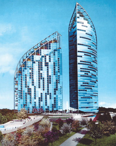
A politician once said that all politics is local. The same is true for good architecture. The redevelopment of the Jefferson Plaza Shopping Center is a good example of this axiom.

Conceptual renderings show a pair of curved glass-and-steel towers rising to points, with trees growing on rooftop terraces, fountains and pools on the grounds and intense lighting at the base of the structures, tapering toward the peaks. One tower might exceed 30 stories, far taller than any building for miles.

"It's going to be real dramatic lighting, along with dramatic water features," St. Raymond said.

The idea, however, is not receiving an entirely enthusiastic welcome in the neighborhood. Some nearby residents protest that it will exacerbate traffic problems, overshadow their houses and stick out, rather than stand out, among Old Jefferson's post-World War II wood frame houses.

So why is this design so unpopular? Seymour D. Fair offers his thoughts:
Architect Daniel Libeskind's above design was not what I had in mind--and I am not completely against multiple floored residential buildings at this site unlike many residents of the surrounding neighborhoods.
Daniel Libeskind is a great architect with soaring ideas for his designs, however like most starchitects, he is not in tune with the local vernacular and traditions. It is likely that the architectural firm was given a survey of the site along with some photos. With this information in hand, the design process begins. The architect may be able to come up with a design that will get noticed. But that is not always a good think. Severe birth defects get noticed too but no one wants one.

The developer and local residents would have been better served had a local architect been retained for the design. Perhaps the local architect's design wouldn't have been as radical but it probably would have been more contextual meaning more sensitive to the local environment and residents. This can't be done from a corner office in Manhattan.

Tuesday, November 14, 2006

River Of Dreams

An earlier post related the agreement between the city and the Port of New Orleans to return part of the riverfront back to the citizens. Now five teams of designers have been chosen to plan the redevelopment.

Nine teams of architects and planners from New Orleans and cities around the world responded to a recent invitation to help plan the redevelopment of a 4.1-mile stretch of publicly owned land along the east bank riverfront.

Among them were at least two winners of the Pritzker Architecture Prize, considered the highest international honor in the field, and architects from London, New York, Los Angeles, Toronto, Mexico City, Edinburgh and other cities.

Famous names such as Frank Gehry, Daniel Libeskind, Zaha Hadid, Reiser + Umemoto, TEN Arquitectos and Chan Krieger Sieniewicz adorn the list of applicants to lead what Sean Cummings calls "reinventing the crescent" that gave the Crescent City its nickname.

(snip)
The foundation of the planning effort is a cooperative endeavor agreement recently agreed to by the city and the Port of New Orleans that spells out what east bank wharves the port will continue to need for maritime activities and what areas will be available for public, nonmaritime redevelopment.

Among other things, the agreement envisions "an uninterrupted and continuous linear green space or riverfront park" along the entire stretch between Jackson and Poland avenues, a "world-class performance venue" at the Louisa Street Wharf or another site, and a hotel and expanded cruise ship terminal at the Julia Street Wharf.

Other possibilities include more cruise ship terminals, hotels, parking garages, museums, an amphitheater, an opera house or a planetarium, according to the city-port document.

Rebirth on the batture

A major goal of the agreement is to expand the area of the riverfront, once devoted entirely to maritime uses, that is available for public use. City leaders have talked about "reclaiming the riverfront" since at least the 1970s, and the process already has resulted in French Quarter and Central Business District attractions such as the Moonwalk, Woldenberg Riverfront Park, the Aquarium of the Americas and the Riverwalk shopping mall.


And the finalists are:

  • Chan Krieger Sieniewicz (planning and urban design), Cambridge, Mass.; Hargreaves Associates (landscape architecture), Cambridge; TEN Arquitectos (architecture), New York; and Eskew + Dumez + Ripple (executive management and urban design), New Orleans.
  • EDAW (planning and landscape architecture), Alexandria, Va.; Frank Gehry (architecture and urban design), Los Angeles; and Marks Associates (landscape consultant), New Orleans.
  • Mathes Brierre Architects, New Orleans; HOK (planning), 23 offices worldwide; and Studio Daniel Libeskind (architecture), New York.
  • Reiser + Umemoto (architecture), New York; Olin Partnership (landscape architecture), Philadelphia; Studio Matrixx (architecture), New Orleans; and Alan Gordon (design consultant).
  • Zaha Hadid Architects, London; Trahan Architects, Baton Rouge; Billes Architecture, New Orleans; Bruce Mau Design, Toronto; and Gross Max Landscape Architects, Edinburgh.
This is a pretty heady group. What is more encouraging is the inclusion of local firms the all the design teams.

After reviewing the location map of the proposed revitalization, I have to ask the question, what will become of the existing wharves in the proposed development area? Don't get me wrong, the wharves are an eyesore and I will be glad to see them go but we cannot ignore economic contribution that the port provides for New Orleans. My guess is they will move either upstream of downstream of downtown New Orleans in either St. Bernard, Jefferson or maybe St. Charles Parish. Or will the Port simply reduce the number of wharves in the city.

The latter seems likely as the port now has more capacity than it needs. However lately, state and local officials have been making trips to Asia and the Persian Gulf to encourage more trade with Louisiana. In addition, Panamanian officials have been visiting Louisiana. This is possibly in conjunction with that country beginning to look at widening the Panama Canal to accommodate larger cargo ships traveling to and from the East/Gulf Coast and Asia. With New Orleans being the largest port in the region and the west coast ports at or near capacity, we are looking at the possibility that New Orleans will see a great up tick in shipping. I wonder if this is being taken into account when redeveloping the riverfront.

I'm not favoring more wharves versus less public access to the river but rather that future needs have to be taken into consideration during the design process.

So to quote Billy Joel:

In the middle of the night
I go walking in my sleep
Through the jungle of doubt
To the river so deep
I know I'm searching for something
Something so undefined
That it can only be seen
By the eyes of the blind
In the middle of the night

Monday, October 23, 2006

Take Me To The River

In a follow-up to earlier posts here and here, New Orleans CityBusiness has a story about an agreement between the city and the Port of New Orleans that would ostensibility return part of the riverfront back to the citizens.

The cooperative endeavor agreement between Mayor C. Ray Nagin and Gary LaGrange, president and CEO of the Port of New Orleans, tentatively scheduled for Thursday as of press time, symbolizes the return of a 4-mile stretch of Mississippi riverfront to citizens. It includes visions of riverside green space and the construction of RiverSphere — a museum and river research center — and a riverfront performing arts venue.
Quote the Talking Heads:

I dont know why I love her like I do
All the changes you put me through

The Mississippi River has always been a threat to New Orleans but likewise, we can't bring ourselves to leave it. Indeed, for New Orleans to be content, she need to be brought closer to it.

Thursday, September 28, 2006

A River Of Inspiration

The New Orleans City Planning Commission has issued request for qualifications (RFQ) to redevelop the Mississippi riverfront.

From NOLA.com:

Some of the world's best-known architects, from Frank Gehry and Rafael Viñoly to Rem Koolhaas and Norman Foster, could have been forgiven a look of puzzlement when they opened their mail one day last week.

There before them was a large black box containing pralines, a can of French Market coffee and chicory, an Emeril Lagasse cookbook, a history of New Orleans' "urban landscape," an iPod full of New Orleans songs and -- of all things -- "Da Mayor in Your Pocket," a device that plays recordings of six of Mayor Ray Nagin's more memorably colorful comments.

The collection was intended to help get the architects into a New Orleans frame of mind as they looked over the city's invitation to get involved in planning a major redevelopment of parts of the riverfront.

Nagin has chosen the New Orleans Building Corp. to oversee the redevelopment planning, and a note to each architect from Sean Cummings, the agency's executive director, said, "We come bearing gifts and an uncommon invitation, one infused with excellence and high aspiration. . . . We welcome you to this city, and we invite you to help reinvent our riverfront."

What might the reinvention involve? Cruise ship terminals, hotels, parking garages, museums, maybe an amphitheater or an opera house or a planetarium, according to the terms under which the port and city agreed to open the area up for redevelopment. Perhaps the plan's highest aspiration is to allow for a riverfront park or green space that would facilitate pedestrian access to the waterway that was responsible for New Orleans' birth and growth, but that for much of the city's history has been almost invisible to many residents.

While the redevelopment has been talked about for many years I hope this effort actually results in the citizens having more access to the most valuable real-estate in the city.

The final draft of Riverfront Vision 2005 can be accessed here.

Monday, September 25, 2006

Oh Rebuild Me A Home, Where The Walkers Can Roam

The district rebuilding plans have been released and can be viewed via the links below:

I haven't been able to fully digest the impact the plans will have on the city as a whole but I can make a few observations.

First of all, the changes to the city scape are not as dramatic as I would have hoped which makes all the more likely that the rebuilding will happen. The recovery plans mostly focus on the restoration and improvement of the damaged infrastructure. That should be a no-brainer. However what is important is that different utilities and infrastructure are given different priorities reflecting their importance to the residents.

Second, one thing that did stand out is that a district's priorities were somewhat consistant with that of other districts with similar income levels. Fore example. The more affluent districts tended to want less parks and more green space along boulevards, mixed-use commercial developments and better streets and sidewalks. The middle-class neighborhoods are looking for some of the same improvements as the affluent areas in addition to pedestrian and bicycle paths whereas the poorer areas tend to concentrate on parks, neighborhood grocery stores and pharmacies as well as improved mass transit and sometimes an expanded street car line.

What is positive about these plans is that they reflect the priorities of the residents and not the dreams of some far-off planners. In addition, these plans are not entirely inconsistent with the city master plan commissioned by the BNOB last fall and was widely criticized.

The next step will be for the various district plans to be coordinated into an overall master plan for the city. Some might say that the earlier master plan was a waste of time and money. Not necessarily. The plan unveiled by the BNOB can serve as a guidepost for integrating the disparate plans into a single cohesive plan that everyone can be happy with.

Wednesday, September 13, 2006

Looks Great. Less Rent

The City Planning Commission has approved developers plans to convert the long vacant Falstaff Brewery into mixed income apartments.

Plans to convert the long-vacant Falstaff Brewery complex at 2600 Gravier St. into the Falstaff Apartments, a 156-unit mixed-income housing development, won approval Tuesday from the New Orleans City Planning Commission.

No one spoke against the project at a public hearing, and both the commission and representatives of nearby neighborhood associations praised it, saying it would restore a deteriorating and highly visible building and provide much-needed low-income housing.

But the commission voted to require more off-street parking spaces than the developers said they can provide, at least right now, placing the project's future in question. The final decision is up to the City Council, which is likely to take up the issue next month.

Whether or not this type of development will be financially achievable is yet to be seen. The way I see it, for the developers to charge the type of rent they are proposing they will be forced to do a renovation without all the bells and whistles the New Orleaneans would like to see return to the old brewery.
It is best remembered by many New Orleanians for the "weather ball" atop the brewery's towering sign. The ball's changing colors and the direction in which the letters of the name "Falstaff" lit up, whether from top to bottom or vice versa, forecast local weather conditions.
These little "whizbang" features cost money and have little return-on-investment. Furthermore, the Falstaff Brewery is located in a part of town that has little if any attraction to tourists. Probably the best we can expect from this development is a spruced-up building that is occupied and generating income. Both results are far better than the status quo.

However, a second phase to this project promises to further enhance the area:

The two-story Silo building at South Dorgenois and Perdido streets, which is separated from the rest of the complex, is designated for commercial development at a later date.

The developers are seeking to change the site's zoning from HI, heavy industrial, to RM-4, multiple-family residential, and to create a "mixed-use planned community district overlay."

Depending on the types of retail spaces envisioned, this could help sweeten the pot for more upscale residents. But the same old bug-a-boo remains; parking.

The biggest issue in dispute before the commission was how many off-street parking spaces the developers should have to provide. Under the zoning law, they should have 259 spaces for the apartments plus 43 for the retail spaces to be developed later.

The commission's staff recommended requiring only 156 spaces for the apartments, one for each unit, and waiving the commercial spaces for now.

But Miller said the developers can provide only 56 to 115 spaces at a site across Gravier Street that holds a former brewery administration building. If the Historic District Landmarks Commission or the council authorizes demolition of that building, the site could hold 115 vehicles. Otherwise, it can hold only 56.

There is a large parking lot between the brewery and South Broad Street, but that is not part of the rezoning request and Miller said that efforts to lease parking spaces in that lot or other nearby lots have been unsuccessful.

Miller asked the commission to require only 125 off-street spaces, which he said would be enough for a complex where many low-income residents are likely to use public transit, not their own cars. But commissioners said other residents are likely to have more than one vehicle per unit.

In the end, the commission voted to require 142 spaces, giving the developers credit for 14 spaces they could put in an alley behind the Silo building that the commission said should instead remain open recreational space.

Parking has always been a problem that that part of town. Dwight Eisenhower once said "If a problem cannot be solved, enlarge it." The Planning Commission needs to understand the real purpose of mass transit. Where large numbers of people are confined to a relatively small space, that space becomes highly valuable and portioning larges parts of it for the sole purpose temporary storage of personal vehicles becomes less economical. This is where mass transit comes in. Since buses and street cars are always in uses and stored "off-site" when not in use, valuable land is not devoted to parking.

This part of New Orleans is much like Downtown in that there is large number of persons in the area during working hours mainly due to the location of the city courthouse down the street at the corner of Tulane and S. Broad St. Renovating the Falstaff Brewery will only that many people to the area.

The solution: the RTA should devise routes to include people coming to the courthouse and leaving the Brewery in the morning and vice versa in the evening. An even more ambitious plan would be to include a street car line down Tulane.

But then again, maybe I've had a few too many.

Saturday, August 26, 2006

A View To A Mill

Tracage condominiums in the Warehouse District is scheduled to begin construction in about 45 days and already they are upsetting the neighboors.

Last week the City Council approved the condos slated for the intersection of John Churchill Chase and Annunciation streets. Opponents say the 24-story building, which falls outside the boundaries of the historic Warehouse District, will ruin the ambiance of a neighborhood consisting mostly of four- to five-story buildings.

Some residents of Lengsfield Lofts on Churchill are also concerned Tracage will block their views.

Joshua Rubenstein, a New Orleans attorney and resident of Lengsfield Lofts, a neighboring condo project, said he is strongly considering suing the city and Tracage.

"I don't think a building of that height is appropriate for the Warehouse District," said Rubenstein, who said the views from his Lengsfield Lofts condo will be totally obscured by Tracage.

My own opinion is that their concern about views and character are overblown. The site of the proposed building is currenly occupied by a couple of non-descript wharehouse buildings that have none of the character that most people associate with the Wharehouse District. And with regard to views, the site is adjacent to the elevated Ponchartrain Expressway and across the street from a recently constructed self-storage facility and no one is complaing about it. In fact, if I had my druthers, I think I would prefer to look at a shiny new tower than a windowless, block-built box of a building .

Also,since the developers are including retail spaces on the first floor, this will bring much needed amenities to this part of the city.

So contrary to its detractors, area residents should stop worrying and learn to love the tower.

Tuesday, May 30, 2006

Petula Clark Is Downtown

When you're alone
When you've got worries,
All the noise and the hurry Seems to help, I know, downtown
Just listen to the music of the traffic in the city
Linger on the sidewalk where the neon signs are pretty
How can you lose?
The lights are much brighter there
You can forget all your troubles,
forget all your cares and go Downtown,
things'll be great when you're Downtown,
no finer place for sure,Downtown,
everything's waiting for you...

Hyatt Hotels is planning a major overhaul of downtown New Orleans.
Under the plan, two state office buildings, city hall, the city hall garage, the New Orleans Shopping Center and parts of the Hyatt would be demolished to make way for a park anchored by the National Jazz Center. City hall would move to the Dominion tower office building, state office buildings would be rebuilt at the site of the Civil District Court building, and the entrance of the Hyatt would move to Loyola Avenue.

The multi-level six-block park will include a 20,000-square foot jazz performance center with seating for 1,000 people, a smaller theater with seating for 300, a children’s theater, workshop, rehearsal studios available to local musicians and an archives for jazz research. The Canal Street streetcar would be extended down Loyola Avenue, connecting the park, sports facilities and public office complexes with the French Quarter and Convention Center.

The result will be a swath of green space leading from Tulane Avenue to the sports complexes of the Superdome and New Orleans Arena surrounded by modern buildings designed by renowned architect Thom Mayne in association with local architect Ray Manning and others. Developers on a panel convened by Hyatt and working with other stake holders from New Orleans envision an area that will be an internationally known destination for the arts and tourism which will be used day and night.

The New Orleans Jazz Orchestra will be based at the Jazz park, which will also be a destination for national touring jazz acts.The project could give lift to the adjacent medical corridor, to long-discussed notions of creating an entertainment district on South Rampart Street and to redeveloping the nearby Union Passenger Terminal. It could also help New Orleans lobby the National Football League for another Super Bowl.
For thirty years, this part of downtown has been dominated by the Superdome and City Hall. It's typically a busy place because so many people do business there. What is missing is is the atmosphere that dominates so much of other parts of the city where people frequent for reasons other than business.

I also think that this will make New Orleans even more attractive for more sporting events in the future. New Orleans has hosted more Superbowls than any other city mainly because of the Superdome's proximity to the French Quarter. If an outdoor complex can be created around the Superdome, this will create another anchor downtown (the other being the French Quarter), the area between these two "magnets" can see growth in activity as people no longer look for the quickest way to get to the FQ, but rather visitors meander from one anchor to the other and visiting shops and restaurants in between. Much like a mall where shoppers go to Macy's and JC Penny but stop at some of the smaller shops in between. Look at it like the world's largest outdoor mall.

UPDATE: Seymour D. Fair at The Third Battle of New Orleans offers more background and insight.

Wednesday, May 03, 2006

On the Waterfront

When Marlon Brando once said "I coulda had class. I coulda been a contender. I coulda been somebody, instead of a bum, which is what I am, let's face it.", he could have been talking obout modern-say New Orleans. But if some developers have their way, New Orleans could once again have class.

After years in the making, a plan to transform the riverfront now looks like a vital nugget in the city's rebuilding. Planners want to tear down warehouses and wharfs and build riverside promenades, condominiums, a cruise ship terminal, a river research center and museum, hotels and an amphitheater on the big crescent bend in the river _ hence, the Crescent City _ to give audiences sweeping views of the New Orleans skyline. Plans call for public and private funds for the projects, which could cost well over $300 million to complete.

"The river and riverfront were the key to the founding of this city, and similarly I think it's the key to the future," said Douglas Meffert, a Tulane University river studies professor involved in the riverside research center. "I think we need to think of the river as our front yard again."

That doesn't mean there wont be difficulties.

But the difficulties of riverfront development are in plain view: A panorama of vacant buildings _ a power plant, factories, warehouses _ overrun with weeds and pigeons.

There have been successes _ at least before Katrina struck. The Rouse Co., the national developer, counted the Riverwalk Marketplace mall as one of its more profitable properties; cruise ship and steamboat companies plied the river; and a sprawling riverfront convention center buzzed with activity. Most of that development was sparked by a World's Fair in 1984 centered on the Mississippi.

But not everyone is buying into this future-by-the-river scenario. Neighborhood groups worry the city's soul would be marred if glitzy condos for out-of-town snowbirds and malls replace the old riverfront.

"New Orleans was founded as a port city in the French Quarter, and to see maritime activity going on there to this day is very exciting," said Nathan Chapman, president of Vieux Carre Property Owners, Residents and Associates Inc., a group that looks after the wishes of French Quarter residents and businesses.

Attempts already have been made to raise the height limit of buildings from 50 feet to 75 feet to accommodate the planned development, said Chris Costello, president of the Faubourg Marigny Improvement Association.

"To go up an extra 25 feet makes it very egregious in our neighborhood," Costello said. The Faubourg Marigny is made up of winding streets and Creole and shotgun cottages with lush backyards immediately down river from the French Quarter.

Instead of fixating on new development, the city should focus on repairing blighted property and turn that into the living space that is so urgently needed, Costello said.

It shouldn't be impossible to overcome these obstacles. In fact, the concernes stated above should be look upon a constraints that will make the developement much more attractive. But if the investors are simply looking to make a quick buck instead making a long-term investment in the city, they might find themselves being made an offer they can't refuse.

Monday, April 10, 2006

View Carre'

The City of New Orleans agreed to allow development of four miles of riverfront property that the city currently owns.

At the first quarterly board meeting of the New Orleans Building Corp., the agency that acts as landlord for city-owned property, the board unanimously authorized Mayor C. Ray Nagin to sign an agreement to open 4 miles of property from Jackson to Polland avenues to developers.

The agreement calls for the city and Port to share revenues generated by development. All proceeds from nonmaritime uses will be split between the city and the Port, 75 percent and 25 percent, respectively.

In late February, the Port of New Orleans Dock Board adopted a resolution to encourage nonmaritime riverfront development.

The move encourages developers who frequently say New Orleans' riverfront is one of its greatest yet most underused assets.

This is a great move and long overdue.

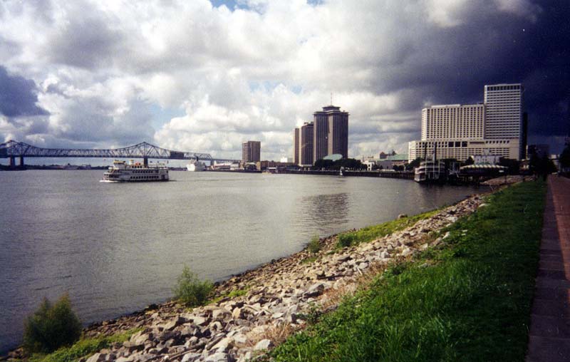
For anyone familiar with the city, the Mississippi River can only be easily viewed from a few locations:
  • Woldenberg Park
  • Riverwalk Mall (still closed due to extensive looting and damage)
  • Audubon Zoo
  • Algiers Point (which affords the best view of the CBD and Vieux Carre')
But for this development to be successful for both the developers and the city, two things need to be assured.
  1. Public access to the riverfront
  2. Height restrictions imposed to prevent "walling-off" the rest of the city from the river.
The second concern has already been addressed.

"We want to make sure they're no turf wars," Cummings said, adding that building hieght concerns will be addressed by CPC.

Chapman said height of buildings will be a major concern for areas such as Bywater.

Now if only Jefferson Parish will follow their lead.